
The Euro model (ECMWF) forecasts Hurricane Michael to make landfall at the Florida Panhandle and Big Ben along the U.S. Gulf Coast on Wednesday afternoon. The model above tracks over a 126-hour period beginning the morning of Wednesday, October 10, 2018.
Hurricane Michael strengthened to a Category 4 Tuesday night and could be the strongest storm to make landfall in the history of the panhandle and potentially for the Gulf Coast ever for the month of October.
Below is the latest forecast cone from the National Hurricane Center (NHC) in Miami, Florida.
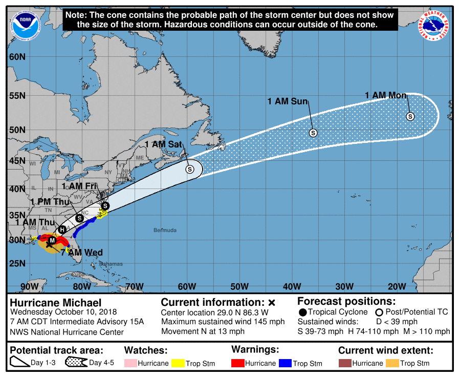
This graphic shows an approximate representation of coastal areas under a hurricane warning (red), hurricane watch (pink), tropical storm warning (blue) and tropical storm watch (yellow). The orange circle indicates the current position of the center of the tropical cyclone. The black line, when selected, and dots show the National Hurricane Center (NHC) forecast track of the center at the times indicated. The dot indicating the forecast center location will be black if the cyclone is forecast to be tropical and will be white with a black outline if the cyclone is forecast to be extratropical. If only an L is displayed, then the system is forecast to be a remnant low. The letter inside the dot indicates the NHC’s forecast intensity for that time:
D: Tropical Depression – wind speed less than 39 MPH
S: Tropical Storm – wind speed between 39 MPH and 73 MPH
H: Hurricane – wind speed between 74 MPH and 110 MPH
M: Major Hurricane – wind speed greater than 110 MPH
Hurricane-force winds extend outward up to 35 miles (55 km) from the center and tropical-storm-force winds extend outward up to 175 miles (280 km). Additional strengthening is expected, and Hurricane Michael is forecast to be a major hurricane at landfall in Florida. Weakening is expected after landfall as Michael moves through the southeastern United States.
Reports from an Air Force Reserve Hurricane Hunter aircraft indicate that maximum sustained winds have increased to near 145 mph (230 km/h) with higher gusts. Michael is an extremely dangerous category 4 hurricane on the Saffir-Simpson Hurricane Wind Scale.
H/T: Tropical Tidbits